

|
|
I got out of that field for a while however as I climbed over the gate I noticed a house across the road to the R with a large window, a Women was standing there talking into a phone watching me intently, I had the feeling she didn't like me in this field, perhaps her Husband owned the property because she looked quite annoyed and was eye-balling me as if to say, ''you have been seen'', ''get out''. I got out from the field anyway, not because of her but because I wanted a new angle for a shot.
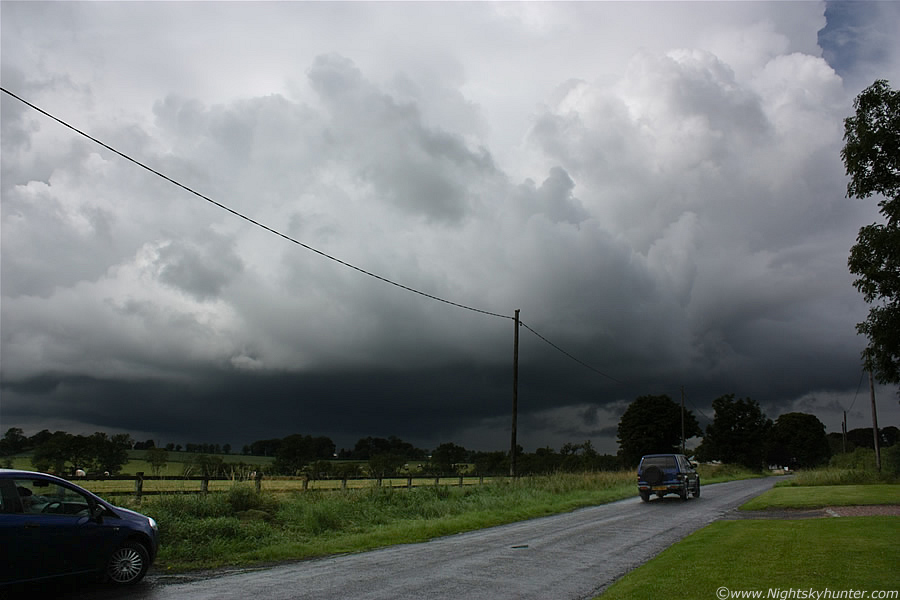 |
On the other side of the road now, that's my car parked on the L, not much of a place to park judging by the size of it but at least it served it's purpose. The only problem with the scene were those poles and cables, almost every shot I took had them in there, I'm not a believer in messing with images though so I decided to leave them on, they could be removed by image processing however I prefer things to look natural, they where there at the time so they would stay there on the images.
 |
I went back into the field again, I couldn't resist the great photo opp with this storm above the beautiful fields. This is the E side of the cell with smaller towers going up ahead of it (R) on the CZ line. To give you an idea how high the updraught was, imagine standing in this field with your head tilted back 90 degrees so the back of your head is resting on your shoulder muscles and then starring far into the sky at the zenith, that's where that tower was. I tried pointing it out to my Mum however she was looking at the incorrect place and couldn't grasp its size so I got back in the car and pointed up through the windscreen, when she finally saw it she said ''OMG''.
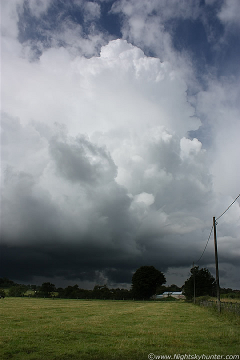 |
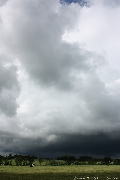
Wide angle vertical shot showing the leading tower of the cell, this was such a beautiful scene. I always try my best to catch storms and convective structures over photogenic foreground, I prefer shooting storms over the countryside, an open road, or a body of water, that way they look more natural and have that Earth-sky connection which every sky shot should have (in my opinion), that way you get a sense of size and scale, in this case the Cows provided the latter. These images were taken on manual mode at ISO100, 800th/sec with the aperture stopped down to F/9, this seemed to work well and produced a very faithful result.
 |
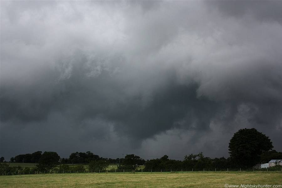
A deep rumble of thunder boomed from under that base again, I had the impression of an angry Bear woken from it's slumber in a cave. I never did see the lightning though, it came from the precip area at centre, I'm sure the drivers on the road on the other side of that tree line got a good view of the flashes. The cell now sported two huge towers, the lead one was of the Calvus type, completely solid, with complex indentations around the tower head like a crown, there were serious air currents moving inside this thing, I'm certain it was producing decent sized hail among the precip. To the L of this tower, dominating the central and rear sections was another Cb, this one was of the Incus (anvil) type and was now taller than the lead tower, and that's saying something!.
 |
There was great motion at the rear and at my side of the cell's flank, I could see strong inflow motion from both areas, see that white cloud tag L of centre hanging down into the darkness?, that was trying its best to funnel, it exhibited strong upwards curling motion, even my Mum, who is not well trained up on these things, saw the motion and commented that a funnel was going to form, I quite agreed with her and was impressed by her observational skills. I watched and waited, the lowering teased us however nothing came from it and no rotation was evident. It would have been awesome if a funnel had spun down from this cell, the scene would have been perfect with that great dark storm structure and a white funnel bending towards the field, it would have made for a stunning wide angle image, however it was not to be today and I was not bothered by the storm's refusal to do so as I was more than happy just standing here watching this wonderful sight.
 |
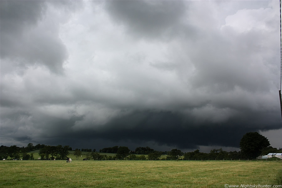
Wide angle vertical capture of the central and rear sections of this massive cell, you can really appreciate its size on this and you can see the new anvil which had grown, which was solid too. Out of frame to the R was the other Calvus updraught which you can see in the 3rd image above this one.
 |
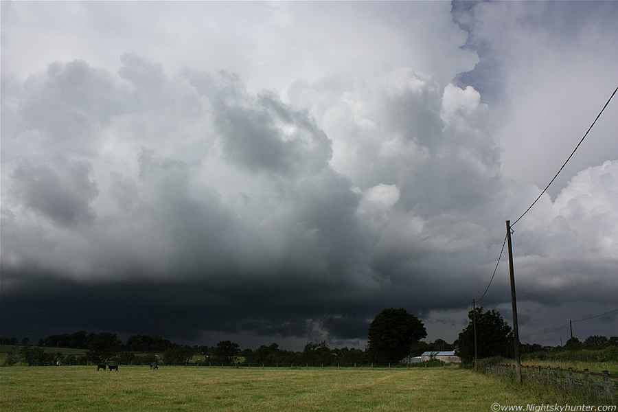
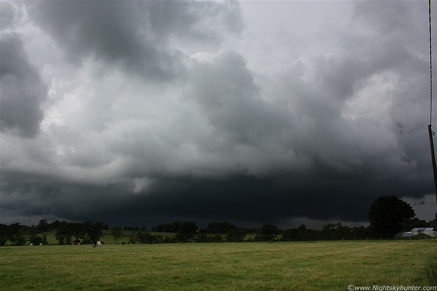
The underside of this line was really nasty looking, look at the solid black lowering forming ahead of the precip core, it's almost touching the ground. My Mum thought a tornado was forming and it would certainly seem like that to the untrained eye however there was nothing to be worried about from that section of the line, that lowering is an outflow feature and is actually a shelf cloud/gust front formed by cool air and precip blowing out from the core and along the surface. The shelf probably looked very cool from the front where it would be seen head-on for anyone located to the SE looking NW, we were viewing it side-on. What really bugs me though is that if I had walked further into the field to my L I would have got these shots without the telegraph poles, perhaps I should have taken more of a risk at the time, my thinking then was, no poles or death by Bull?, it was an easy decision.
 |
Just a really cool scene here with the dark storm clouds contrasting with the rich and bright fields. This is the kind of weather I love to be out in, it's the classic Summer set-up which I adore, slow moving photogenic thunderstorms, substantial heat and humidity, and being able to stand there watching this thing at close range in a t-shirt in complete comfort while thunder rumbled and intense sunlight burned my neck, it brought back vibrant memories of watching July storms back at home during 2007. I felt happy and in my element here, I knew this would be a great memory to cherish from the Summer of 2010.
 |
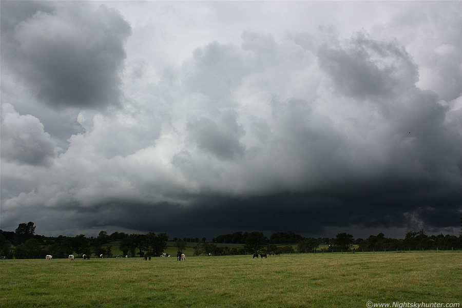
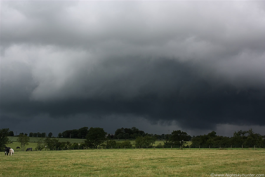
The cell became outflow dominant, these are what's known as 'popcorn' or 'pulse' storms. Due to a lack of strong wind shear the cells were not organised, or only slightly so in some cases today. This means that with no inflow-outflow separation the precip would eventually fall back through the base choking off the inflow so the cell can't breath in it's much needed supply of warm moist air. When this outflow overruns the inflow the storm is said to be outflow dominant which is the best time to see good shelf clouds. Outflow features can look visually stunning though and often take the form of clouds and scud moving at low levels across the ground with great motion. This image at 29mm shows a dramatic theatre of rapidly moving scud ahead of the precip. Nice big 'lowering' at centre which actually did look very suspicious for a while!.
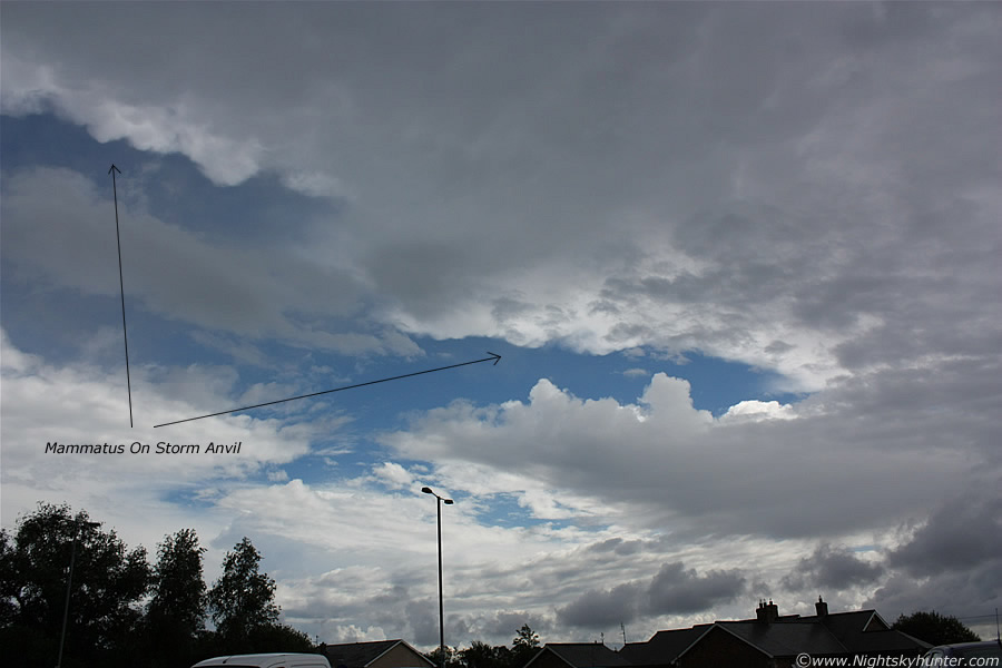 |
With no more thunder we decided to call it a day, it was around 16.00 so we headed home. While on the road between Antrim and Toome clear gaps appeared in the mid level cloud and I got a good glimpse of the mighty anvil from that storm which covered a huge area of sky stretching back to the N, the anvil was still solid, and along the edge of the Incus shield was a row of solid mammatus clouds, I couldn't believe the height of them, they looked to have been easily in excess of 30,000ft, probably more!. I put down the passenger window and managed to get this snap at 18mm before the anvil became obscured by cloud.
Video clip I put together showing the updraught base of the first storm, then footage of the CZ line convection, then ending with a brief clip of that large cell and the mammatus on the way home. Torrential rain was our companion all the way home and as we drove further N and W we moved into an area of more stable air and frontal rainfall. An occluded front was moving down from the N so I had made a good decision to chase further S today. Back home I went on the internet and checked the latest, wow, there had been non stop action in E, S, and SE NI all afternoon with hundreds of c-g strikes from countless storms which had formed on several CZ lines and along the trough making this one of three major thunderstorm days here in the last week. Flooding was the main issue which made the news including power cuts from the lightning. I was very happy with the chase, I saw three thunderstorms, heard thunder from other storms further away, saw explosive convection and great photogenic storm structure. The only thing missing was a funnel or tornado, however there's always next time!. Thanks for reading.
Martin McKenna